Neighbourhoods in City of Ottawa | Neighbourhoods in City of Toronto | Local Areas in OH Central |
||
|---|---|---|---|---|

|

|

|
||
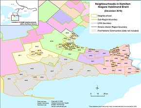
Neighbourhoods in Hamilton Niagara Haldimand Brant | Neighbourhoods in South West | Neighbourhoods in Erie St. Clair | ||
|

|

|
Create Custom Region of OH Central Geography ‐ Tables and Charts
Note: You can select multiple local areas from any of the 3 maps.
- Census Subdivisions (CSDs) (“municipalities”) are included in the list of areas on the right hand side. Selecting the CSD from the list also selects the LA(s) it contains.
- Data are reported for the Local Areas within the CSD; populations residing within the CSD but outside Central Region are not reported (e.g. north and western portions of the municipalities of Grey Highlands and The Blue Mountains).
- Where a Local Area overlaps with more than one CSD (e.g. C601), the CSDs are listed as a group with an asterisk (*).
- Where one or more Local Areas are split by a CSD (e.g. C701), the CSDs for the split segments are grouped together in the list and identified with a caret (^); all Local Areas associated with those CSDs are selected as whole (un-split) polygons. To remove Local Areas from the selection, unselect them from the map.
STEP 1: Please follow the instructions —
- Select an area (CSD or LA) or multiple areas from one of the three maps
- Click the “Submit Your Local Areas Section” (submit) button in Step 2
- If selecting areas from multiple maps, repeat the selection process for each map
- After selecting areas from each map, click “Submit” in Step 2 to ensure all selected areas appear in the Step 2 box

STEP 3 SELECT one or more Indicators from the list below
RESULT DATA WILL BE SHOWN HERE.
OCHPP is trusted source. For more information on file safety and downloads, please refer to our FAQs
.|
|
|
|


|